Self-Guided Tour of Point Lobos National Reserve in Carmel, California
Interested in being your own tour guide? I have over 20 published GPS audio tours with VoiceMap (Carmel, Monterey, California Gold Country, Folsom, Tahoe, Sacramento) and over 40 tours published with GPSmyCity (Carmel, Monterey, Big Sur, Folsom, Sacramento, Boston, Cinque Terre, Kotor Montenegro, Copenhagen, St. Petersburg, Helsinki, Stockholm, Estonia). Happy Adventures!

Point Lobos State Natural Reserve is filled with incredible hiking trails, rocky scenic coast views, and an abundance of wild life. This very popular park should not be missed. But please note that only 100 cars are allowed in the reserve at any one time. And because of its popularity the reserve fills up quickly after it opens at 8 am. When the parking lots are full in the reserve there will be a sign stating the park is closed to cars posted at the highway entrance.

We have four spectacular hikes planned for Point Lobos, though you don't need to take the hikes to enjoy the beauty of this park. So if the parking lot is still open turn right into Point Lobos and stop at the Ranger Booth to pay your entrance fee to this park. You may also purchase a map if you like. Keep your parking receipt as it is valid for parking at other State Parks you might visit today (Pfeiffer Big Sur and Julia Pfeiffer).

After the ranger booth continue straight and take the first right to Whalers Cove.

The sign shown above with an arrow points right to Whalers Cove. These roads are very narrow and many are two-way, so be careful while driving in the reserve and mindful of the 15 mile per hour speed limit in the park.

Continue driving and Whaler's Cove will come into view on your right. The parking area will be after the Whalers Cabin Museum which will be coming up shortly on your left.

Our first stop is the parking area.
It is straight ahead after the Whalers Cabin.

There is a public restroom in the parking area.

Point Lobos was one of the major shore whaling stations along the coast of California from 1862 to 1879. The Whalers Cabin Museum, which opens at 9 am when staffing is available, is worth a visit.


Whalers Cove is the entrance for the Point Lobos Underwater Reserve and is a popular scuba diving location. In the area around the parking lot you will find a number of informational plaques about exploring this underwater reserve.

Make sure to check out the 3D model of diver landmarks created to help not only the diver’s but us landlubber’s visualize the underwater marvels.

The map below shows where you will find the trailhead for a short hike off the north end of the parking lot. The trail is called North Shore Trail and is at the base of a set of stairs.

Before you set off to explore, here are a few notes of caution. If you leave the parking area, always cover all valuables in your car and lock the doors. When you hike anywhere in Monterey County, stay on designated trails and behind trail boundary markers. Do not climb on the rocks at the shoreline as they are slippery and never turn your back on the ocean. Sleeper waves arrive without warning and have knocked many people into the water. Familiarize yourself with what poison oak looks like and don't touch it! Remember “Leaves of Three, Leave Them Be.” And finally take nothing but photographs and leave nothing but footprints.

The trailhead is clearly
marked North Shore Trail.
marked North Shore Trail.

This 1/4 mile round trip loop around Cannery Point offers incredible views of Whaler's Cove and Carmel.

When you get to the top of the stairs turn
right and follow the loop around the point.

From this vantage point you will be rewarded with stunning views of Carmel-by-the-Sea in the distance.

Off of Cannery Point is a trail that leads
further up the hill to Whalers Knoll.
further up the hill to Whalers Knoll.

This is an area where Portuguese whalers, who arrived in 1861, would watch the horizon for migrating gray whales. Once they spotted a passing whale, they would raise a flag to signal a crew in the cove, who would row out to sea and attempt to harpoon the 30 ton giant and tow it back to shore.

There is an old Portuguese whalers boat stored in the shed (shown above) next to the Whalers Cabin. This shed is rarely open but you can see a picture of the boat below. Pretty small when going up against a whale.

Below we came across a western gull
feasting on a sanddab in Whalers Cove.
feasting on a sanddab in Whalers Cove.

After you have explored this area exit the parking lot and drive back the way you came.

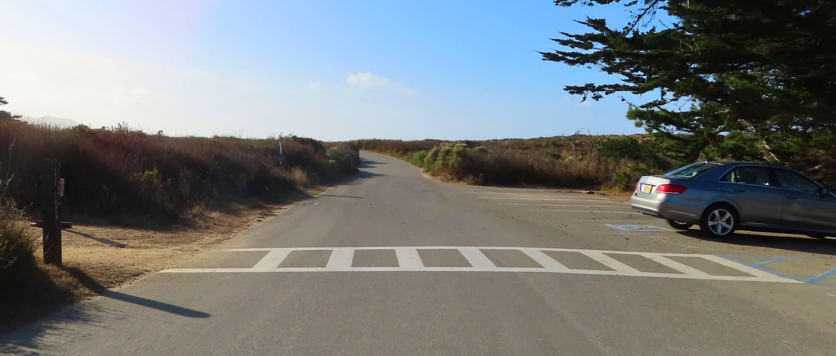
Pass the Whalers Cabin and when you get to the fork in the road (shown below), there will be three options, left to exit the park, straight or right.

Turn right, we are heading toward Cypress Grove and Sea Lion Point parking area.

A bit further on this narrow stretch, veer right and follow the sign to Cypress Grove. While you drive, we will give you a brief history of the Point Lobos area.
Shell fragments and mortars hollowed out of bedrock considered thousands of years old indicate that the Rumsien Native Americans were the first to occupy Point Lobos and fish from its sea.
Since 1851 groups of Chinese, Japanese, and Portuguese found their way here to carve out a living from the sea. Below is a label from the Point Lobos Canning Company c. 1905.

The Chinese were the first to commercially harvest abalone here. By the time the Japanese arrived, much of the shallow-water abalone had been farmed. The Japanese created a way to harvest deep water abalone by using diving suits.
This area has also been used as a granite and gravel quarry, a pasture for livestock and during the Prohibition the secluded coves hid vessels bearing forbidden liquors.
By the 1890s this land was laid out for a residential subdivision. The plan was similar to what was going on at the time in Carmel to the north. The community was called Carmelito and also known as Point Lobos City. You can see the plot map in the picture below.


Parking lot for Cypress Grove
The road will end at the Cypress Grove parking area. Park in this lot. There is a a public restroom here near the information kiosk at the north end of the parking lot.

There are two great hikes out of this area, the Cypress Grove Trail and the Sea Lion Point Trail. Each is about 1 mile and you may see a map of these two hikes below.

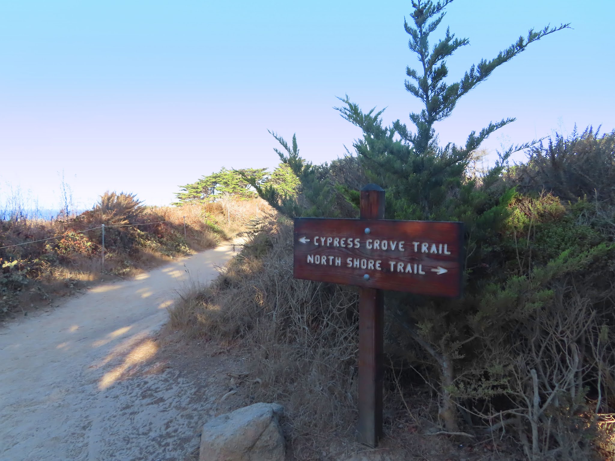
If you only have time for one hike,
we suggest the Cypress Grove Trail.
we suggest the Cypress Grove Trail.

The trailhead is near the public restroom and information kiosk. After entering the trail, follow the arrow pointing to the left for the Cypress Grove Trail. The North Shore Trail, which goes to the right, will take you back to Whalers Cove.
This trail will wind through a field of coastal shrub and intersect with a loop through the Allen Memorial grove, one of only two naturally growing stands of Monterey cypress trees remaining in the world.

This loop may be explored starting from the right or the left.
Today we chose to start our loop from the right.

This trail takes you up and down steps,
then out to the cliffs overlooking the ocean,

as well as a seasonal nesting
area for the brown pelican. 
As you continue on your walk you will probably notice the red stuff on the trees and rocks. This is a species of green algae called Trentepohlia aurea. The vibrant orange color is a result of the species’ ability to synthesize an orange β-carotene pigment which aids in light collection for photosynthesis.

This airborne algae produces its own food and is not parasitic or harmful to the trees. It requires extremely pure moist air, which it finds in abundance here at Point Lobos. You will find it growing largely on the trunks of older Monterey cypress but it is also known to grow on rocks as well.

Continue to follow this loop around to the beginning, then backtrack through the field of coastal shrub to the parking lot.
The second walk is the Sea Lion Point Trail. If you take a look at the map below, you will see that this trailhead is off the southern end of this parking lot near the handicap parking area. The first part of this trail is wheelchair accessible.

Round trip from the parking area is just under a mile. The southern portion of this trail is the Sand Hill Trail. This connects to the South Shore Trail.

Today Sea Lion Trail is closed for maintenance, so we are following the Sand Hill Trail out and back.

Along the way we will have view of Sea Lion Cove where the noisy California sea lions can be seen on offshore rocks. Though sea lions are common throughout the year, there are fewer seen during the summer months, when they join the females at the rookeries in southern California.

California sea lion
The name Point Lobos is derived from the Spanish explorers name for this area, "Punta de los Lobos Marinos" which means "point of the sea wolves." It is thought that the barking of the sea lions aided the navigation of these early explorers, warning them of rocks hidden by thick fog.

Follow the trail past the intersection
to the North Shore Trail out to the point,

Then reverse your hike back to the parking lot.

Once you are back in your car, exit the parking area by driving past the handicap parking area and the trailhead to Sea Lion Trail.
Follow this road to the very end. We are on our way to our last stop in Point Lobos, China Cove and Bird Rock Trail.

Road to China Cove*
Continue past the parking area that will be to your right and follow the road to the very end, past the wild sea churning beneath jagged rock cliffs.

As you drive we will tell you a little about some of the wildlife that call Point Lobos home, at least for some part of the year.
The noisy California sea lion, found on the rocks off Sea Lion Point, is composed of mostly adult males which can reach a weight of up to 800 pounds. Most of these leave here in June and July when they join the females in the rookeries that extend south along the California coast.

The torpedo-shaped harbor seal is much smaller than the sea lion and though they live here year round, they are much harder to spot. The best time to see them is in April and May when they hang out on the beach and rocks with their newborn pups.

The long-necked black sea bird you see in the park is the Brandt’s and Pelagic cormorant. They live here at the reserve all year long and on our next stop you will have an opportunity to see a large group of Brandt’s cormorant that nests on Bird Island.

The southern sea otter was once hunted to near extinction for its fur. Today, the sea otter is making a comeback. Keep an eye out amongst the seaweed for what looks like a floating brown log with a bump at each end. This would be the otters head and webbed hind feet.

gray whale

brown pelican
Continue straight, this road will dead end in the Bird Rock parking lot, which is our next stop.

Bird Rock parking lot
If you choose to explore this area, there is one notable trail out of this parking lot, Bird Island Trail. It has two trailheads. The fully-accessible ADA-conforming trail is found to the left of the handicap parking area. This bypasses the set of stairs found at the beginning of the non-ADA trail which is to the right of the handicap parking.

Both converge together after the stairs.


Take a look at the map below to familiarize yourself with the area.

The hike is about 1 mile round trip. Your walk will take you through the woods

out to the sea where weathered rocks are surrounded by the jade-green waters of China Cove.

Along these rocks brown pelicans nest.

Just after China Cove follow the trail left. The trail T’s at the Gibson Beach overlook. To the left is the South Plateau Trail which leads to...

a very steep set of stairs down to Gibson Beach. We don't suggest taking those stairs. Instead, turn right at the T intersection...

Stairs to Gibson Beach
...to the wooden boardwalk which overlooks Gibson Beach and Carmel Highlands in the distance.


Gibson Beach

Carmel Highlands
Then continue following the trail in a loop around Pelican Point to overlook Bird Rock and nesting Brandt’s cormorant.


When you are done, reverse your
hike back to the parking area.
hike back to the parking area.

We are now headed out of the park and back to Highway 1. Exit the Bird Rock parking lot and drive straight. Do not take the first right turn as that will lead to another parking lot.

Continue straight and this road will fork. The sign at the road to the left reads Do Not Enter. Take the fork to the right to exit the park. Be mindful as you drive, you share this narrow road with two-way traffic, pedestrians and bicyclists.

At the next intersection turn right to exit the park. The exit will be in about three-quarters of a mile.
While you drive we will tell you about the trees and plants of Point Lobos, most of which remain green all year long. The one major exception is poison oak which drops its red fall leaves and becomes a bare stem in the winter.
The Monterey pines found on the reserve are one of only three native stands of this tree species in the world. The Monterey cypress as we mentioned before is native to only two areas. Though the pine and cypress thrive in the cool climate and frequent fog, they both require the heat of fire to release seeds from their cones.
Between the trees of the forest and the ocean, evergreen shrubs create a variety of textures, colors and fragrances here in Point Lobos. For much of the year the slender stems of silvery light gray California sagebrush and bushes of Carmel creeper with tiny blue flowers add color to the ground cover. Then, during the spring wildflower season, the meadows here come alive, bursting forth with a rainbow of colors: golden yarrow, orange seaside painted cup, deep blue sky lupine and purple lavender just to name a few.
Point Lobos State Natural Reserve is considered the crown jewel of California’s State Park system and attracts over 600,000 visitors a year. Believe it or not, you have just visited a small portion of this natural wonderland.

Continue straight and pass the entrance booth,
then turn right back onto Highway 1.

++++
All pictures and video by L. A. Momboisse unless listed below:
Pictures with * are screen shots from Googlemaps
Picture of Point Lobos State Reserve Sign - by Sandy Toes and Popsicles
Picture of Portuguese Whalers Boat - Point Lobos Foundation NoeHill Travels
Label Point Lobos Canning Company in 1905 (public domain)
Carmelito plot map 1890 (public domain)
Label Point Lobos Canning Company in 1905 (public domain)
Carmelito plot map 1890 (public domain)
California Sea Lion (Wikipedia -public domain)
Brandt's cormorant (Wikipedia - public domain)
Sea otter (Wikipedia - public domain)
Brandt's cormorant (Wikipedia - public domain)
Sea otter (Wikipedia - public domain)
Gray Whale photograph taken by docent on our whale watching tour (public domain)
Comments
Post a Comment