California Coast: Carmel-by-the-Sea to Santa Cruz Driving Tour
Interested in being your own tour guide? I have over 20 published GPS audio tours with VoiceMap (Carmel, Monterey, California Gold Country, Folsom, Tahoe, Sacramento) and over 40 tours published with GPSmyCity (Carmel, Monterey, Big Sur, Folsom, Sacramento, Boston, Cinque Terre, Kotor Montenegro, Copenhagen, St. Petersburg, Helsinki, Stockholm, Estonia, Covadonga, Spain, Montserrat, Spain, Manresa, Spain, Loyola, Spain, Santiago de Compostela, Spain, Fatima, Portugal, San Sebastian Garabandal, Spain, Lourdes, France, Santarem, Portugal). Happy Adventures!

If you are interested in this driving tour as an audio tour, our companion audio tour will be available the end of February 2021 on VoiceMap. Tours are listed under Monterey Peninsula and Santa Cruz. To use VoiceMap, you will need to download the VoiceMap app from Apple Store or Google Play. This app is free, there is a charge for the audio driving tour. Happy Adventures and enjoy the tour!
****
All of the stops and hikes on this driving tour are optional. The parking fees, for parks and beaches as well as town parking lots are not included in the price of this tour.
Alright, it is time to get started.

1850's Farm House
You should be parked in the parking lot of the Mission Ranch. Back in the late 1800s this was a dairy ranch run by the Martin Family. Their ranch house was the white two-story house with the sign that reads 1850s Farm House.
During the mid 1940s the grounds and buildings were used for a recreation club and then as an Officer's Club during World War II.
In 1950, off duty from Fort Ord, twenty-one year old Clint Eastwood made his way to Mission Ranch where it was love at first sight. Thirty-six years later Clint purchased Mission Ranch, saving it from being developed into 60 plus residential units.

Clint Eastwood, who still owns the Mission Ranch Inn and Restaurant, renovated the resort, preserving it with the flavor and façade of the 1850s, thus keeping this historic property essentially, "locked in time." You can learn more about this inn on our Carmel Mission Area Walking Tour.

Alright it is time to get going on our driving tour. Exit the Mission Ranch parking lot and turn right on Dolores Street.


From the Carmel Mission, make a left after the stop sign onto Rio Road and use the left turn lane to turn left onto Santa Lucia. Continue straight on Santa Lucia for three blocks, then turn right onto Dolores Street. We are going to drive through the "Golden Rectangle" Carmel's highly desirable residential area where the typical 1,600 square foot home can sell for over $2 million dollars.
Continue straight, we will be on Dolores for nine blocks. And use caution at each intersection even if there is no stop sign.


Carmel-by-the-Sea has a rich history and you may read more about this history on my blog Carmel City (1852 to 1910) or take one of our numerous walking tours of Carmel.


Next on your right, built in 1926 by Comstock for $1,200 is Carmel's iconic landmark the Tuck Box. Along this block you will also find wine rooms, a park, art galleries, and specialty stores.

At the stop sign ahead, watch for pedestrians and carefully cross Ocean Avenue. Then turn right onto Sixth Avenue.


Continue through the next intersection. Then coming up on your right is Devendorf Park, named after Carmel's co-founder, Frank Devendorf.


Up ahead we will enter the Comstock's Historic Hill District and the largest concentration of Comstock's Fairy Tale cottages. I will point out a few.

After you pass through the intersection ahead, on your left will be Comstock's Tudor Storybook style personal residence. The cute house next door was originally his studio office.


Look to your right for the light colored one story with teal colored trim. The gate has glass panels. Honeymoon Cottage was built by Comstock in 1928.


This was built in 1939, by a former mayor of Carmel, Allen Knight for his nautical collection. Today it is a private residence.

Continue straight on Guadalupe. We will be on this street for four blocks. Our next turn is a right onto Second Avenue then a left onto Carpenter Street.

Continue straight on Carpenter, past the Vendange Carmel Inn and Carpenter Street will veer to the right. This is the route most Carmelites use to enter and exit Carmel as it avoids the traffic on Ocean Avenue. Stay on Carpenter. In 1/4 mile turn left onto Highway 1 North.

Continue straight on Highway 1 past the Highway 68 West exit sign on your right up ahead. This exit leads to Pebble Beach, the 17 Mile Drive and Pacific Grove.
Shortly you will descend Carmel Hill toward Monterey, and on a clear day the bay should come into view.

From 1915 to 1940 another group of Carmelites walked this hill daily, this time to go to high school.
 |
| Carmel Hill 1908 |
Continue straight on Highway 1 past the next exit, 399B. We are not stopping here, but this is the exit for Fisherman’s Wharf and Cannery Row in Monterey. We have created two fun walking tours for this area; both are listed under Monterey Peninsula. In this tours you will learn about the roll Monterey played in the history of California. But here is a very short summary.

Before the Spaniards arrived, the Rumsien native peoples inhabited this area and would be the first native people to be seen and documented by the Spanish explorers in Northern California.
In 1542, Spanish explorer Juan Rodgriquez Cabrillo is credited with being the first European to visit this part of Central California. Upon entering what would become Monterey Bay, he named it Bahia de Los Pinos or Bay of the Pines.
Sixty years after Cabrillo, Sebastian Vizcaino landed here and renamed the area Puerto de Monterey and claimed the land for Spain in 1602.

In 1770 Gaspar de Portola and Franciscan priest Junipero Serra arrived at Monterey Bay. Fr. Serra established mission San Carlos de Borromeo in Monterey that year and in 1771 moved the mission, now commonly known as Carmel Mission Basilica, to its present location, which we drove by at the beginning of this tour.

Officers of Commodore Sloat raise the U.S. flag over Monterey
By 1778, Monterey had become the capital of Alta California. The Spanish would rule until 1821 when Mexico took over. On July 7, 1846 during the Battle of Monterey, Captain Sloat captured Monterey unopposed and claimed California for the United States. Four year later California became the thirty-first state of the Union.
Continue driving north on Highway 1, while I tell you about a man who would become one of Monterey County's largest land owners.

The story goes like this. After California was admitted into the Union, land grant owners were required to authenticate their claims. This was a difficult task, many land grants ended up sold for pennies on the dollar. And David Jacks took full advantage of this opportunity.
In 1853 Delos Ashley was hired to help legalize title to 30,000 acres of land on the Monterey Peninsula. Ashley was successful, but when the City of Monterey could not pay for his services, Ashley suggested they auction the land.
Ashley and Jacks were the only two bidders, purchasing the land for around $1000 in 1859. Ten years later, Ashley sold his interest to Jacks.
By 1903 Jacks owned about 60,000 acres of Monterey County, including what are today parts of Monterey, Pacific Grove, and Pebble Beach as well as the communities you are driving through now, Del Rey Oaks, Seaside, and Fort Ord.

Ohlone (by Louis Choris)
What is now this asphalt highway at one time thousands of years ago was used as a hunting ground for the Ohlone Native Americans. In the 1770s the Juan Bautista de Anza expedition camped here. During the 1800s the area was used for cattle, dairy and farming and from 1917 to 1994 it was a U.S. Army facility.
Our next turn off is Exit 406 Lightfighter Drive. While you drive I want to take you back to April of 1917, when the War Department purchased 15,000 acres of land right here from the heirs of David Jacks. Camp Gigling, as it was called, served as a maneuver area and artillery field for Monterey Presidio regiments.
In 1933, the site was renamed Camp Ord in honor of Union Army Major General Edward Ord, and improvements began with the construction of administrative buildings, and barracks.

On July 1, 1940, the War Department activated the 7th Infantry Division here under the command of General Joseph Stilwell. The horse-drawn 76th Field Artillery became the first unit of this new division. 1,400 horses were housed in temporary corrals until fort stables were completed in 1941. A few of these buildings have been preserved and now serve as the Marina Equestrian Center.
In 1941, Camp Ord became Fort Ord and operated as a training center. During the Korean War years, television and film actors Clint Eastwood, Martin Milner, and David Janssen served their basic training here. Other Fort Ord soldiers of note include Defense Secretary Leon Panetta, musician Jerry Garcia and actor Leonard Nimoy.
During the Vietnam War Fort Ord was a major staging area for units departing for Asia, and home to basic combat and advanced infantry training for over half a million soldiers.

The base was decommissioned in 1991, and closed three years later. Between 1940 and 1975 an estimated 1.5 million soldiers trained there. And to any serviceperson who passed through this base I would just like to take this time to say, Thank you for your service.

Shortly off to your left you should see white cement bunkers buried in the sand dunes. These were part of Distance Firing Range 8 one of the 15 ranges at Fort Ord. Currently the bunkers are part of the Fort Ord State Park.
The 1.5 million soldiers who trained here over the years left an archive of bullets, artillery projectiles, rockets, hand grenades, land mines and dynamite in the soil. In 1994 the Fort Ord Reuse Authority was established to redevelop the former military installation.
And today, a quarter century later, after crews removed nearly 50,000 pounds of munitions debris many of the acres have been cleared for civilian reuse.
Some of these new uses include the campus of California State University Monterey Bay and Fort Ord Dunes State Park.

Exit to your right and continue up the off ramp. At the intersection turn right onto Lightfighter Drive. We are on our way to Fort Ord Dunes State Park.
Stay to your left and continue through the first stop signal. At the next stop signal use the left lane to turn left onto 2nd Avenue.

Stay to the left. After the first stop sign, continue past the California State Monterey Bay Otter Sports Complex and turn left onto Divarty Street.

Fort Ord Dunes State Park was created during the clean up by the Fort Ord Reuse Authority. The serenity of this oceanfront park makes it hard to believe that at one time this was a firing range and that over 719,000 pieces of spent ammunition were removed from the sand there.
 |
| Old Fort Ord Barracks |
Continue straight, on your right will be two-story dilapidated buildings, these are old Fort Ord army barracks.


Yet this peaceful area has a somber feel, as one can’t help but think that some of the men and women who trained here on this beautiful beach bluff never returned from war, paying the ultimate price for our freedom.


Turn left onto 8th Street and cross over Highway 1 to the entrance of Fort Ord Dunes State Park. The parking area is open from 8 am to sunset daily.

State Park is along the coast.

At this time there is no parking fee for this state park.


out along the sand path


Use the left turn lane to turn left after the stop sign onto Second Avenue. Continue straight on 2nd. In 1/2 mile, it will be after you pass the shopping center, use the outer left-hand lane to turn left onto Imjin Parkway.


We are on our way to Pezzini Farms in Castroville, home of the Green Globe artichoke. Native to the Mediterranean, this large thistle-like plant grown, for its edible fleshy flower head, is delicious served hot or cold, boiled or fried, with or without sauce.


In 1958, the same year that Tony Pezzini was born, his father Guido opened the families first roadside produce stand on Highway 156. This became a very popular stop for locals and visitors traveling to the Monterey Peninsula from San Jose. I know my family never passed the stand without stopping to buy a few artichokes!

In 1974 after Highway 1 from Santa Cruz to Monterey was completed, Guido opened a roadside stand on Nashua Road down the street from their home. Tony took over the business in 1983 and continues to run the ranch with his wife and sons. They produce and pack over 80,000 artichokes annually.


How did this land become a colorful patchwork of rich agricultural fields? Well if it had been up to Monterey County Assessor W. P. McGarvey it never would have. In 1865 Mr. McGarvey concluded that the climate, soils, landscape and proximity to water sources would prevent Monterey County from ever becoming a productive agricultural community. He couldn't have been more wrong.

Frankly, it is northern Monterey County’s proximity to the coast, its temperate climate and highly fertile soils that have unquestionably contributed to this areas proud tradition of farming and agriculture since the mid-1800s.
Monterey county utilizes two types of agricultural systems. They are called extensive and intensive.

Extensive agriculture requires a low level of labor and capital and is used mainly for cattle grazing, dairy farming and grain production.
Intensive agriculture requires more capital, higher levels of labor, and more technology, such as the use of irrigation. The first intensive crop grown on a large scale here in Monterey county were Claus Spreckels sugar beets in the late 1860s. We will hear more about him later on this tour.

Today Monterey county agriculture grows over 150 crops, contributes over $4 billion per year to the county’s economy and produces a large percentage of our nation’s food supply. In 2019 the top crops grown here were leaf lettuce, strawberries, head lettuce and broccoli.
Stay in the right lane and keep driving straight. You should be able to see the white building out in the middle of the fields in the distance off to your right, that's Pezzini's.

Use the right lane to exit 414A at Nashau Road if you would like to visit Pezzini's. At the stop sign turn right onto Nashau Road. Then right into Pezzini Farms parking area.

Take some time to enjoy this family run farm stand, a local favorite! There is also a public restroom here.


Once on Highway 1, stay in the right lane and follow the signs for 156 East to Castroville. Then stay to the right for Exit 414B to Highway 156 East to Castroville and San Jose.
We are on our way to downtown Castroville and a favorite childhood roadside attraction of mine, the World's Largest Artichoke. It is one of just 195 roadside attractions across the United States that can claim to be the worlds largest! And I'm sure you'll agree when you see it that it is right up there with your states World's Largest Roadside Attraction.

At the stop signal use the left lane to turn left onto CA-183, also called Merritt Street in this location. Continue in the center lane and cross over Highway 156 into downtown Castroville.

As you cross back over the freeway, look ahead and to your right for the Giant Artichoke restaurant sign.


I am taking you down the main street in Castroville because since the highway bypassed it years ago, Merritt Street gets few visitors, and this hardworking farming town deserves more attention.
Castroville was founded in 1863 by Juan Batista Castro. Juan laid out the town of Castroville and then created a lottery to give away 100 of the town lots to any person who would clear the land and build a home. By 1875 the town had 900 residents, two hotels, two churches, and three saloons.

Today with a population of over 6,500, Castroville is largely centered around agriculture. 100 percent of all artichokes grown commercially in the United States are grown in California and three-fourths of those are grown here in Castroville.

Up until 2009, Castroville was the home to the Artichoke Festival. This popular festival, which serves up everything artichoke, includes a parade, cooking demonstrations, wine tasting, car and art show now takes place on at the Monterey County Fair Grounds each summer. A highlight includes crowning the Artichoke Queen. The first queen crowned in 1948 was Norma Jeane Mortenson, most know her as Marilyn Monroe.

Keep going straight on Merritt and shortly the town will give way to agricultural fields and the junction for Highway 1 North to Santa Cruz.

At the junction up ahead, turn right onto Highway 1 north toward Santa Cruz. As you travel along this section of Highway 1. Take a look diagonally to your right. In the distance you will see two tall cement stacks. That is the Moss Landing Power Plant.

Constructed in 1949 by Pacific Gas & Electric, not only are they landmarks to visitors traveling by land or by sea, but for nearly half a century these 500-foot twin stacks churned out enough electricity to power millions of homes and businesses. PG & E sold the plant in 1998 and there have been a few owners since. Though the latest owners, Dynegy continues to produce power through two small units that came online in 2002, they pulled the plug on the two large stacks in December 2017 due to their inefficiency.

Up ahead on your left you will pass by two farm fresh roadside stands, Thistle Hut and Barn Fresh Produce.
One-half mile after Barn Fresh Produce we will turn off the freeway at Portrero Road to visit Moss Landing.
This sleepy town is located about midway along Monterey Bay, at the mouth of the Elkhorn Slough, and the head of the Monterey Bay Submarine Canyon.

This submarine canyon is also part of the Monterey Bay National Marine Sanctuary, one of only 14 federally protected marine sanctuaries in the country. Established in 1992, this sanctuary runs 360 miles along the California coast from Marin County in the north to San Luis Obispo County in the south.

Enter the left turn lane and slow to a stop. Diagonally ahead of you is the yellow building. The frontage road that parallels Highway 1 is to the right of the yellow building.
Make sure to watch for oncoming traffic. When it is safe to do so cross Highway 1 and make an immediate hard right onto the frontage road that parallels Highway 1. This is Moss Landing Road. Continue Straight on Moss Landing Road.

Up ahead on your left after the cemetery, you will pass the Moss Landing marine Laboratories.


This tiny little hamlet was named after Texas ship captain Charles Moss. Moss brought his family here to homestead in 1866.
Moss and his partner Portuguese whaler Cato Vierra constructed a 200 foot landing and made a good business shipping all kinds of products north to San Francisco.

you will find a number of quirky one of a kind art pieces on display.


Every day, whale-watching, sport fishing and Elkhorn Slough tours leave this harbor heading out to sea.

After the stop sign next to the Whole Enchilada carefully turn left onto Highway 1 going north.


There are no formal tours here, but as you drive through the ranch to the parking area you may observe some of the farming activity and you will see a lot of cows.
It is also a great place to observe large groups of migrating birds. During the fall and spring, the tops of the eucalyptus trees are filled with migrating Great Blue Heron and Great Egret, it is quite a site. Last November I came across a flock of hundreds of noisy tricolored blackbirds that filled the trees. It really depends on the season and what is passing through.


Excavation around the slough uncovered mounds of broken shells and bones, giving us clues that the Ohlone probably fished in its waters, feasted on its shellfish and camped in the groves of oaks along the shore.


By the early 1940s, the Kaiser Refractory plant would bring heavy industry to these shores, extracting magnesium from seawater for the manufacture of heat-resistant bricks. And finally in 1949 PG&E built that big power plant I already told you about.
It can be said that over the last several thousand years Elkhorn Slough has supported a number of diverse communities and a variety of business ventures.

In 1971, the Nature Conservancy purchased an area of the slough wetlands for conservation. Public and private partners continued to acquire wetland and upland areas which led to its designation in 1979 as the Elkhorn Slough National Estuarine Research Reserve.
In 2012, the Nature Conservancy transferred ownership of the majority of its holdings to the Elkhorn Slough Foundation which continues to manage the land and harbors.
Renowned for its outstanding birding, kayaking and hiking opportunities, Elkhorn Slough provides a critical habitat for more than 135 aquatic birds, 550 marine invertebrate, and over 100 fish species as well as a diverse number of plants.
Designated a Ramsar site in 2018, this intergovernmental environmental organization established by UNESCO provides for the conservation of the slough wetlands and sustainable use of their resources.

This is the historic Struve Dairy, named after Danish immigrant Hans Struve, a grain farmer who arrive here around 1860 and lived in this home.

Santa Cruz county has over 29 miles of coastline and extends 10 miles inland to the crest of the Santa Cruz Mountains. We will be traveling along the coast and visit Aptos and Capitola before arriving in the city of Santa Cruz.

After you cross under the overpass for West Riverside Drive in Watsonville, watch for a dilapidated two-story Queen Anne Victorian house sitting right in the middle of an agricultural field. This is the Redman-Hirahara Farmstead.

In the 1930s this home passed to the Hirahara family, one of the first Japanese-American households to own farmland in the area. After Pearl Harbor the Hirahara family was sent to an internment camp, but they were able to maintain ownership of their farm and after the war returned to their home.

In 1998 this home was added to the National Registry of Historic Places and in 2005 purchased by the Redman-Hirahara Foundation which currently farms the land around the home. When the foundation raises enough money to restore the home, they plan on transforming it into a Visitor and Cultural Education center.
Our next stop is in 2 and 1/2 miles at Clearview Orchard apple farm. This working apple farm, which grows certified organic Fuji, Honey Crisp and Mutsu apples, is open Saturday and Sunday from 10 am to 4 pm during apple season, which runs September through October.
Clearview Fuji
If you happen to be taking this tour on a weekend during apple season, and you would like to experience picking your own apples right off the tree this detour off the highway is for you.
Use the right lane to exit Highway 1 at Exit 428 Buena Vista Drive if you want to visit Clearview Orchards farm, otherwise continue along Highway 1.
At the end of the off ramp, turn right onto Buena Vista Drive, then make an immediate left onto Lower Trabing Road, which turns into Trabing Road.
The entrance to the farm stand is about ½ mile down this road. If the gate is open the farm stand is open. Trabing Road has no outlet, so you will be coming back in this direction to get back onto Highway 1.

Look for the driveway off to your right and stop here at the Clear View Orchards Apple Barn to purchase your fresh produce or arrange to pick your own if it is apple season.
When you are finished picking apples at Clear View Orchards, turn left back onto Trabing Road. Continue straight, we are headed back the way we came to resume traveling north on Highway 1.
Our next stop is in about 7 miles, the Forest of Nisene Marks State Park in Aptos.
Aptos evolved from an Indian village, to a Mexican cattle rancho, to Claus Spreckels’ thoroughbred horse ranch and sugar refinery, then it became a lumber town, an apple processing center and ultimately a resort town. It also was the epicenter of the devastating 6.9 magnitude 1989 Loma Prieta earthquake.
Claus Spreckels was born in Germany in 1828 and immigrated to New York in 1846. In 1856 Claus, his wife and children relocated to San Francisco and began a brewery. But it would be sugar not hops where he would make his fortune.

Claus built his first sugar refinery in 1867 and used some of the wealth he acquired from this venture to purchase the former Mexican land grant Rancho Aptos in 1872.
It was here in Aptos that he built another sugar refinery and began to experiment with growing sugar beets. In 1888 he established the Western Beet Sugar Company in Watsonville, and a few years later moved his main operation to the Salinas area where the town of Spreckels would form around his Sugar Company factory.
Between 1884 and 1924, Redwood timber harvesting became a major industry in Aptos. Most of the lumber came from what is today the Nisene Marks State Park.
Sitting on the eastern edge of the city of Aptos, this park consists of 10,000 acres of majestic old-growth coast redwood. But just a mere century ago most of the redwoods were gone, clear-cut for split stuff and tanbark.

Redwood logging actually began here around 1850 with oxen teams dragging wooden skids laden with timber down the hillsides. In 1882, the Loma Prieta Lumber Company convinced Southern Pacific Railroad to build a dedicated branch line to their lumber company and a year later this railroad line was hauling huge redwood logs to mills in the surrounding area. In 1924, after processing 140 million board feet of redwood from the forest, the Loma Prieta Mill was dismantled and closed.
In the early 1950s Monterey County rancher and real estate investor Nisene Marks purchased the holdings of the Loma Prieta Lumber company. In 1963, the Marks family deeded the land to the State for use as a public park.
Today, after years of forest regeneration and preservation efforts, about 80% of this park is again covered in magnificent coast redwood. Shortly, you will have the opportunity, if you like, to hike some of the trails near the park entrance and view these impressive trees.


Continue on Soquel Drive, through the first traffic signal. Then Soquel Drive will curve left ahead and cross under a railroad trestle. Continue straight under the trestle to the stop signal. There will be a colorful mural on your right.

Continue across the Aptos Creek Bridge into Aptos Village the original town site of Aptos and prepare to turn left after the auto body shops which will be ahead on your right, onto Aptos Creek Road.
You will be on Aptos Creek Road for a little under one mile as we head to the entrance to the Forest of Nisene Marks. Use caution on this narrow two-way road.


There is an entrance fee to park here. If you prefer not to visit this park just tell the ranger at the entrance booth that you do not plan on visiting the park but would just like to turn around. You will be allowed to do so and then head back the way you came.

Use your map to locate the Loop Trail off of the parking area. Just after entering the trail you will come to a fork. The trail to the right is the Waggoner Overlook Trail and leads to a overlook of the Aptos Creek below.


We are on our way to Seacliff State Beach, so follow Spreckels Drive under the overpass. Then at the stop sign, turn right onto Seacliff Drive and continue straight.
Within two blocks it will curve left then fork right and become Center Avenue. Follow on to Center Avenue. Follow Center Avenue as it forks off to the right ahead and continue on Center.
The land around Seacliff beach was part of the Rancho Aptos Mexican land granted to Rafael Castro in 1833. That same year, Castro and Claus Spreckels built a wharf at the beach that would turn Seacliff into a bustling shipping port.
Almost 100 years later in the mid 1920s summer vacation homes began springing up on the bluffs overlooking the wharf and the beach. By 1931, Seacliff would become one of California’s first state beaches.
Use the left lane to turn left after the stop sign ahead onto State Park Drive and follow this to the Seacliff State Beach entrance booth. If you visited the Forest of Nisene Marks earlier today you may use this receipt to park at Seacliff State Beach. The parking area is to the left of the entrance booth. If you do not have a previous parking receipt and you want to visit this park you will have to pay a parking fee.
If you prefer not to stop at this state park just tell the Park Ranger at the entrance booth and he will let you turn around. Then exit the park via State Park Drive and follow State Park Drive about 1/4 mile to the entrance to Highway 1 North to Santa Cruz. Otherwise park here to explore the area.

Palo Alto 1920


the southern end of the parking lot.


Once you are back on the highway, our next exit is for Capitola in 2 1/2 miles. Stay to your right while you drive and I will tell you bit about our next stop.
Capitola was part of Rancho Soquel the Mexican land grant deeded to Martina Castro in 1833. Years later, Frederick Hihn acquired the land and in 1869 he leased the beach area to Samuel Hall. Five years later Hall opened Camp Capitola, the first seaside resort on the Pacific Coast.

As Camp Capitola began to prosper, Hihn saw the value in this land and in 1882 subdivided the lots for sale. Over time this grew into the vacation resort town of Capitola-by-the-Sea.
In 1919 Hihn's daughter sold the property to Henry Allen Rispin who designed the Mediterranean style Venetian Court Apartments on the edge of Soquel Creek lagoon.

Venetian Court
Today Capitola is filled with boutique shops and charming restaurants. The best way to explore Capitola's downtown is on foot, however parking is metered and can cost anywhere from .50 to $10 depending on the parking lot. And with many of the streets being one-way, it can make navigating this town difficult. So I will lead you on a driving tour through downtown passing as many of the highlights as possible and then back to the freeway.
In case you want to try your luck at parking and walking the town, I will point out a reasonably priced parking lot that is about 1/4 mile from the beach.
Up ahead is the sign for Exit 437 to Capitola. Use the right lane to exit at Porter Street and Bay Avenue Exit 437. Exit here and turn left onto Bay Avenue.

Welcome to the charming beach community of Capitola. At the next stop sign, use the right lane to turn right onto Capitola Avenue. Then watch for blue and white parking signs. These are for the Beach and Village Parking lot about 1/2 mile away. It's reasonably priced at .50 per hour. If you choose to park there to explore the town by foot, the downtown and beach are 1/4 mile from this parking lot.


Once you are done, turn left back onto Capitola Avenue and we will lead you through a driving tour of Capitola before we heading back to the freeway.

Capitola History Museum
Continue straight under the Capitola Trestle built in 1874 and you are on the outskirts of downtown.
Turn right at the stop sign ahead onto Stockton Avenue.

As you cross the Stockton Avenue Bridge, look to your left. That is the Capitola Wharf and beach. The tan and multi-colored stucco buildings are the Venetian Court Hotel.
.jpg)
At the end of the bridge follow the yield sign and turn right onto Wharf Road. We are going to turn around and head back into town, so pass under the overpass, drive past the colorful mural and at the next intersection turn left onto Lincoln Ave.

We are using this neighborhood to turn around. Enjoy these typical Capitola beach cottages and at the corner ahead, turn left onto Emerald Street. Then left onto Prospect. As you drive you will have a lovely view to your right back over the coast.
At the end of Prospect turn right back onto Lincoln then immediate right onto Wharf Road to complete our turn around back to town.
.jpg)


Slow down a bit a turn right at the next intersection onto Esplanade. There is no stop sign, but pedestrians have the right of way.


This is Capitola's busy main street filled with restaurants and shops. Drive slowly all the way to the end of Esplanade and the parking area. Here you will have views of the beach and wharf.


After the stop sign continue straight and head up the hill. Our next turn is a left onto Bay Avenue in about 1/4 mile.
After you pass the colorful mural, veer left onto Bay Avenue.
If you are hungry for a snack we will be passing one of Capitola's best bakeries momentarily, Gayle's. In fact people come from out of town just to visit Gayle's.


We will be on Highway 1 for about 3 miles. Our next exit is 442. As you drive we will give you a brief history of Santa Cruz.
Basing their livelihood on the abundance of marine resources, the first people to inhabit this area were the Native Ohlones who settled along the coast from Marin to Monterey County.
In 1769 the Spanish Portola Expedition arrived and began to establish pueblos and missions in Alta California. Fr. Junipero Serra would found the first nine of those 21 missions. You visited one of them earlier on this tour, the Carmel Mission. After Serra’s death in 1784 Fr. Lausen took over leadership of the missionary system and established the 12th California Mission at Santa Cruz on September 25, 1791.
The lumber industry served a dual purpose, clearing the land for agriculture, and producing building materials. In the 1850s, Santa Cruz was one of only two major suppliers of wood to San Francisco for construction.
Due to its mild climate, Santa Cruz also became a prominent resort community, with the first tourist hotels, summer cottages and bath houses constructed in the 1860s.
As the population continued to grow, Santa Cruz was incorporated in 1866. The railroad arrived in 1876 with a line from Watsonville and a second line in 1880 that connected Santa Cruz to San Francisco.
In 1903, entrepreneur Fred Swanton formed the Santa Cruz Beach Company and erected 200 tent cottages across from the beach. A year later they had been transformed into wooden vacation cottages.

In the early 1900s Swanton built the Neptune Casino complex on Santa Cruz beach. Today this National Historic Landmark is known as the Santa Cruz Beach Boardwalk.
In the mid-1960s the University of California established a Santa Cruz campus near what had been the Henry Cowell limestone quarry during the 1850s. The University has an interesting mascot, the Banana Slug.
Now over 155 years old, Santa Cruz is known for its redwood forests, moderate climate, its unique historic neighborhoods, beautiful beaches, a place to catch a good wave, and countercultural politically progressive liberal politics.

Alright we are almost to Santa Cruz. Stay to the left for Highway1 Santa Cruz and Half Moon Bay. The freeway will make a large curve around and re-enter Highway 1.
Welcome to Santa Cruz. After the stop signal, continue straight on Ocean Street.
There will be two more stop signals before we turn right onto Water Street. We are on our way to the Santa Cruz Mission State Historic Park.
This historic park sits atop Mission Hill and features the only building left of the 12th California Mission, Mission Santa Cruz, which was founded by Franciscan Father Lasuen in 1791.
At the next traffic light, use the right lane to turn right onto Water Street, as we wind our way past some of the sights of Santa Cruz before ending our driving tour from Carmel, at the Santa Cruz Beach Boardwalk.
Continue straight on Water Street and cross over the San Lorenzo River. After the stop signal continue straight on Water Street.

Ahead on your right is the Santa Cruz clock tower, known for being the meeting place for protests that take place in town.

The sculpture next to the clock is entitled Collateral Damage: A Reality of War. Erected in 1995 to commemorate the 50th anniversary of the atomic bombing of Hiroshima and Nagasaki.
After the clock, Water Street veers right and becomes Mission Street. Continue onto Mission.


Turn right onto School Street. To your left on the corner is a half-scale replica of the original Santa Cruz Mission. Continue to the end of School Street.

At the end of the street is an adobe which was home for Native American families during mission times. Today it is a museum. Next to the adobe is the entrance for the Santa Cruz Mission State Park.

If you would like to stop here, you may park on School Street where parking is available.

Here you will find Holy Cross Church, which sits on the site of the original mission church.
At the corner turn left onto Sylvar Street. Take your time as we wind our way through the streets of the Historic Mission District. Many of the Victorian homes here were built in the 1880s.

At the corner turn right on to Mission Street, and notice the 1887 blue two story Stick Eastlake Victorian on the right corner. Once on Mission you will find both sides of the street lined with Victorians.
Coming up on your right on Green Street, is an 1850 two story yellow with green trim Italianate Victorian. Notice the carriage step in front. This served as Santa Cruz' first Protestant church.

Those train tracks lead off to the left through the Mission Street tunnel, along the San Lorenzo River Gorge, through Henry Cowell Redwoods State Park into Roaring Camp in Felton.
When this train route opened in 1875, the narrow gauge railroad carried lumber from the Santa Cruz Mountains to the mills and wharves on Monterey Bay. Today tourists may ride vintage locomotives from Roaring Camp to the Beach at Santa Cruz.
To your right you will pass the Santa Cruz Art Center. In operation since 1971, the art center is home to arts-minded businesses such as dance, theater and galleries.

After the stop sign, follow Center Street as it veers slightly left and continue on Center Street. We have reached Santa Cruz's downtown municipal area. On your right is the Santa Cruz City Hall, Civic Auditorium and Fire Station No. 1.

City Hall

Civic Auditorium
At the corner after the fire station, turn right onto Walnut Street. This block of Walnut, lined with London Plane trees and historic Victorians, was the first residential street in Santa Cruz. Drive slowly as you enjoy the charming homes built between 1870 and 1930.


.jpg)

Turn right onto Center and continue straight for about one mile. We are headed to the Beach Hill Historic District. During the 1890s, ship captains built their homes here, high on the hill so as to easily see when vessels were entering the bay.
After the railroad arrived in 1875, the Beach Hill district became a resort area with hotels and large Victorian mansions.
It also has ties to the film industry. In 1960, Alfred Hitchcock found his inspiration for the Bates mansion for his movie "Psycho," in a dilapidated Victorian on Third Street. This Victorian was originally built around 1863 for Dr. Kittredge and run as the McCray Hotel from 1926 to 1943.

Hitchcock had a replica of this mansion built at his film studio, and it still stands on the Universal Studios backlot near Los Angeles.
Today Hitchcock’s inspiration for the Bates mansion has been fully restored and serves as the Sunshine Villa Assisted Living Retirement Home. I will point it out later.
Continue straight and stay to the right. To your right notice the soccer field. Just past the soccer field enter the round-about.
Pass the Public Parking and West Cliff Drive exits and take the third exit off the round-about which is Pacific Street.
Up ahead, turn left onto Second Street, then an immediate left onto Font Street.
We are going to drive by Hitchcock's inspiration for his Bates mansion.

Up the steps between the rock wall next to the sign for Sunshine Villa to your right is the wood Victorian that was the inspiration for the Bates mansion.
Continue straight along side Sunshine Villa, through the Beach Hill Historic District where ship captains built lavish homes in the 1890s.
Ahead at the corner turn right onto Main Street. The mustard yellow Victorian on your left was built in 1891. Quite the view one would have had from the crows nest of that mansion down to the beach.
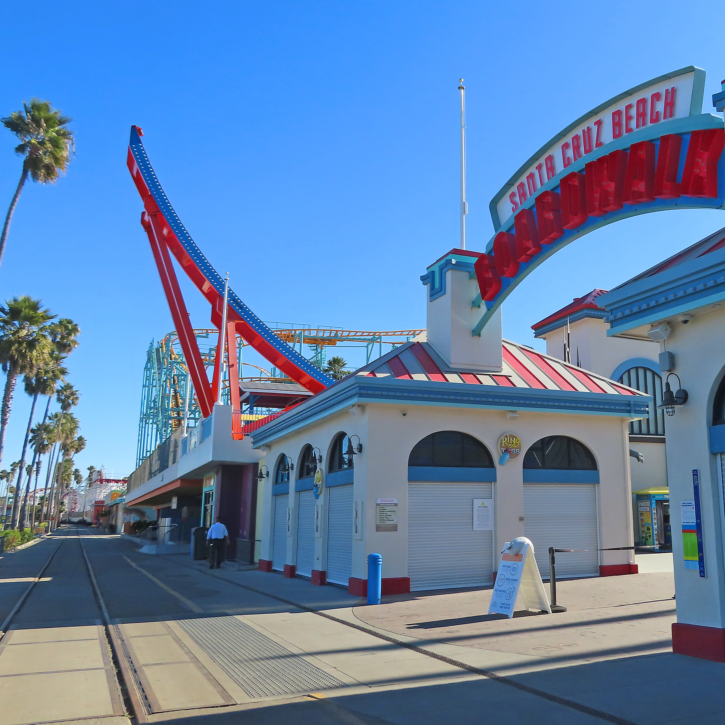
We are on our way to the Santa Cruz Beach Boardwalk. Though entrance to the Boardwalk is free, parking is $5. If you want to ride the 1911 Loof Carousel or 1924 Giant Dipper wooden roller coaster, tickets may be purchased at the park.
If you choose to stop here it is a short walk to the Municipal Wharf where you will find restaurants and gift stores.


Now this is where I will be leaving you. I hope that you have enjoyed your driving tour from Carmel-by-the-Sea to Santa Cruz and all of the stops in between.
Until next time, Happy Adventures!
Black and white photograph of Carmel Hill (Harrison Memorial Library Local History Branch)
David Jacks (Wikipedia public domain)
Ohlone (painting by Louis Choris, Wikipedia public domain)
Black and white photo Fort Ord Firing Range (Monterey Herald 1965)
Three pictures of Pezzini's from Pezzini Farms website
Artichoke Field - Artichoke.org
Monterey Bay Submarine Canyon - Frontiers in Earth Science
Elkhorn Slough 1870s (painting by Leon Trousset)
Oyster Farm Elkhorn Slough - https://www.elkhornslough.org/1931-oyster-farming/
James Redman (Find a Grave )
Redman-Hirahara House (National Register)
Clearview Fuji Apple - http://clearvieworchards.com/contact/
Claus Spreckles Wikipedia
S S Palo Alto - picture from 1920 and picture at pier from 2013 - Wikipedia
The 1904 Neptune Casino with horses and trolley - Wikipedia
Bates Mansion and Bates Hotel Universal Studios (Wikipedia)
Comments
Post a Comment